Fayl:Un-senegal.png
Faylın orijinalı (3.092 × 2.367 piksel, fayl həcmi: 2,74 MB, MIME növü: image/png)
| Bu fayl "Vikimedia Commons"dadır və digər layihələrdə istifadə edilə bilər. |
 |
Faylın təsvir səhifəsinə get |
Xülasə
| İzah |
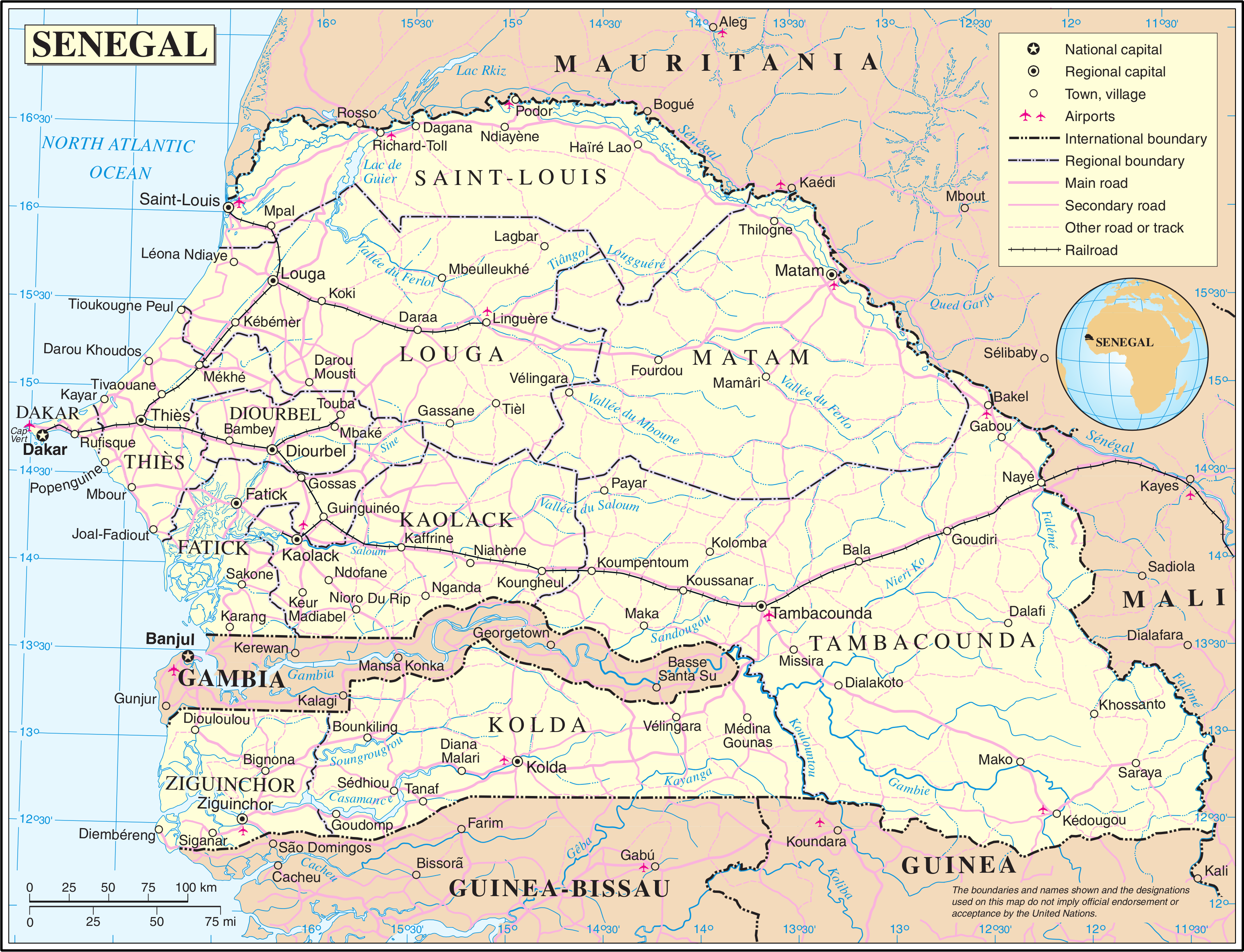
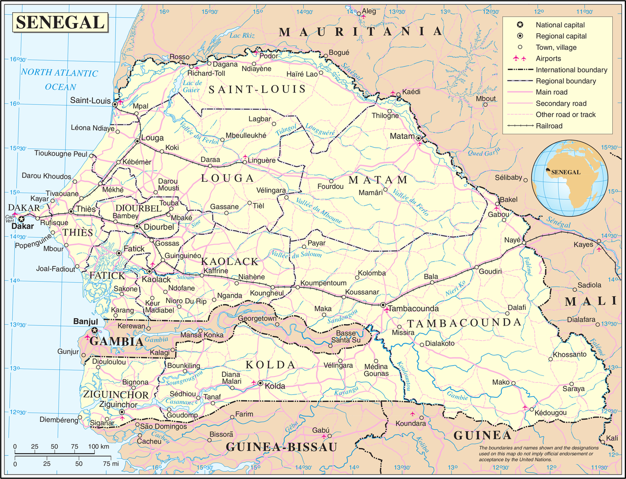
English: Administrative map of the 11 former regions of Senegal from 21 February 2002 to 10 september 2008, before the separation of the three new regions of Kédougou (from the region of Tambacounda), Sédhiou (from the region of Ziguinchor) and Kaffrine (from the region of Kaolack). Français : Carte administrative des 11 anciennes régions du Sénégal du 21 février 2002 au 10 septembre 2008, avant la séparation des trois nouvelles régions de Kédougou (de la région de Tambacounda), Sédhiou (de la région de Ziguinchor) et Kaffrine (de la région de Kaolack). |
| Tarix | |
| Mənbə | Based on a reference map created in 2004 by the United Nations and published in PDF format. |
| Müəllif | Original by the United Nations. Cropped as required by the licence to derive a PNG version. |
Lisenziya
| This image is a map derived from a United Nations map.
Unless stated otherwise, UN maps are to be considered in the public domain. This applies worldwide. UN maps are, in principle, open source material and you can use them in your work or for making your own map. UN requests however that you delete the UN name, logo and reference number upon any modification to the map. Content of your map will be your responsibility. You can state in your publication, if you wish, something like: based on UN map … (map name, map number, revision number and date). See: Geospatial Information Section. And: Geospatial, location data for a better world. |
 |
Faylın tarixçəsi
Faylın əvvəlki versiyasını görmək üçün gün/tarix bölməsindəki tarixlərə klikləyin.
| Tarix/Vaxt | Kiçik şəkil | Ölçülər | İstifadəçi | Şərh | |
|---|---|---|---|---|---|
| indiki | 02:13, 24 oktyabr 2007 | | 3.092 × 2.367 (2,74 MB) | Jeroen | {{UN map}} Category:Maps of Senegal |
Fayl keçidləri
Aşağıdakı səhifə bu faylı istifadə edir:
Faylın qlobal istifadəsi
Bu fayl aşağıdakı vikilərdə istifadə olunur:
- en.wikipedia.org layihəsində istifadəsi
- es.wikipedia.org layihəsində istifadəsi
- eu.wikipedia.org layihəsində istifadəsi
- fr.wikipedia.org layihəsində istifadəsi
- it.wikipedia.org layihəsində istifadəsi
- nl.wikipedia.org layihəsində istifadəsi
- pl.wiktionary.org layihəsində istifadəsi
- uk.wikipedia.org layihəsində istifadəsi
- wo.wikipedia.org layihəsində istifadəsi
- zh-yue.wikipedia.org layihəsində istifadəsi