Fayl:Bancdarguin oli 2019362.jpg

Vikipediya, azad ensiklopediya
Naviqasiyaya keç Axtarışa keç

Faylın orijinalı(720 × 700 piksel, fayl həcmi: 372 KB, MIME növü: image/jpeg)

Bu fayl "Vikimedia Commons"dadır
və digər layihələrdə istifadə edilə bilər.
təsvir səhifəsi
təsvir səhifəsi
Faylın təsvir səhifəsinə get

Xülasə

İzah
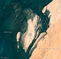
English: When viewed from space, the shoals, seagrass beds, and mudflats of Mauritania’s Banc d'Arguin National Park often blend with sand and sea in beautiful ways.

So it was on December 28, 2019, when the Operational Land Imager (OLI) on Landsat 8 captured this natural-color image of the park’s shallow coastal waters. The mostly barren dunes on the shore drew a contrast with the maze of coastal mudflats (dark brown) and shallow seagrass beds (green) that grow beneath a few meters of water. Deeper channels (dark blue) meander and flow among the sea grass and sandy shoals.

While signs of life are rare on this mostly arid land, the upwelling of cool, nutrient-rich water offshore causes the park’s coastal areas to burst with marine life. Whales, dolphins, and seals all make appearances. Thriving finfish and shellfish populations attract migratory birds to breeding sites here. Expansive tidal mudflats support upwards of 2 million shorebirds, making Banc d'Arguin one of the largest meeting places for Palaearctic birds in the world. Several endangered marine mammals occasionally turn up, notably monk seals and humpback dolphins.

But Landsat does more than deliver an occasional pretty picture. Scientists have analyzed 20 years of satellite observations and found that the park’s extensive seagrass beds have remained remarkably healthy and resilient, despite weathering occasional damage from storms and dust that temporarily killed grasses in certain areas.

NASA Earth Observatory image by Lauren Dauphin, using Landsat data from the U.S. Geological Survey. Caption by Adam Voiland.
Tarix December 28, 2019 JPEG
Mənbə https://earthobservatory.nasa.gov/images/146600/beautiful-banc-darguin-national-park?src=eoa-iotd
Müəllif NASA Earth Observatory
İcazə
(Faylın təkrar istifadəsi)
Public domain This file is in the public domain in the United States because it was solely created by NASA. NASA copyright policy states that "NASA material is not protected by copyright unless noted". (See Template:PD-USGov, NASA copyright policy page or JPL Image Use Policy.)
Warnings:

Captions

Add a one-line explanation of what this file represents

Items portrayed in this file

təsvir edir

MIME type ingilis

image/jpeg

checksum ingilis

4dac0ac38b14bd0844300136a718fabeb0aabd5a

data size ingilis

381.175 Bayt

720 piksel

Faylın tarixçəsi

Faylın əvvəlki versiyasını görmək üçün gün/tarix bölməsindəki tarixlərə klikləyin.

Tarix/VaxtKiçik şəkilÖlçülərİstifadəçiŞərh
indiki13:53, 23 aprel 202013:53, 23 aprel 2020 tarixindəki versiyanın kiçildilmiş görüntüsü720 × 700 (372 KB)Tillman{{Information |description ={{en|1=When viewed from space, the shoals, seagrass beds, and mudflats of Mauritania’s Banc d'Arguin National Park often blend with sand and sea in beautiful ways. So it was on December 28, 2019, when the Operational Land Imager (OLI) on Landsat 8 captured this natural-color image of the park’s shallow coastal waters. The mostly barren dunes on the shore drew a contrast with the maze of coastal mudflats (dark brown) and shallow seagrass beds (green) that grow be...

Aşağıdakı səhifə bu faylı istifadə edir:

Faylın qlobal istifadəsi

Bu fayl aşağıdakı vikilərdə istifadə olunur: