Fayl:Piri Reis map of Europe and the Mediterranean Sea.jpg

Faylın orijinalı (2.000 × 1.375 piksel, fayl həcmi: 510 KB, MIME növü: image/jpeg)
| Bu fayl "Vikimedia Commons"dadır və digər layihələrdə istifadə edilə bilər. |
 |
Faylın təsvir səhifəsinə get |
Xülasə
| İzah |
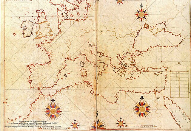
العربية: نسخة عن خريطة تعود لِأواخر القرن السادس عشر الميلادي، منقولة عن الأصل المُنتجة سنة 1525م والمُدرجة ضمن كتاب البحريَّة من تأليف پيري ريِّس
English: a late 16th century copy of the 1525 Kitab-ı Bahriye (Book of Navigation) by Piri Reis |
||||||||||||||||||||
| Tarix | late 16th century (Original upload date on en:wikipedia by Flavius Belisarius, 13 August 2007) | ||||||||||||||||||||
| Mənbə | Library of Istanbul University. No:6605 | ||||||||||||||||||||
| Müəllif |
|
||||||||||||||||||||

|
Derivate Works

Lisenziya
|
This work is in the public domain in its country of origin and other countries and areas where the copyright term is the author's life plus 70 years or fewer.
| |
| This file has been identified as being free of known restrictions under copyright law, including all related and neighboring rights. | |
Faylın tarixçəsi
Faylın əvvəlki versiyasını görmək üçün gün/tarix bölməsindəki tarixlərə klikləyin.
| Tarix/Vaxt | Kiçik şəkil | Ölçülər | İstifadəçi | Şərh | |
|---|---|---|---|---|---|
| indiki | 20:12, 5 avqust 2008 | | 2.000 × 1.375 (510 KB) | Xauxa | {{Information |Description=Piri Reis map of Europe, the Mediterranean Sea and North Africa from his Kitab-ı Bahriye (Book of Navigation), 1521-1525 |Source=en:Piri Reis map of Europe and the Mediterranean Sea.jpg |Date=drawn 1513, uploaded on en:wik |
Fayl keçidləri
Aşağıdakı səhifə bu faylı istifadə edir:
Faylın qlobal istifadəsi
Bu fayl aşağıdakı vikilərdə istifadə olunur:
- ar.wikipedia.org layihəsində istifadəsi
- بوابة:الدولة العثمانية/صورة
- بوابة:جغرافيا/صورة مختارة/أرشيف
- ويكيبيديا:صور مختارة/رسومات وجداول وخرائط/خرائط
- بيري ريس
- ويكيبيديا:ترشيحات الصور المختارة/خريطة حوض المتوسط لبيري ريس
- ويكيبيديا:صورة اليوم المختارة/سبتمبر 2018
- قالب:صورة اليوم المختارة/2018-09-04
- بوابة:الدولة العثمانية/صورة مختارة/47
- بوابة:جغرافيا/صورة مختارة/14
- ويكيبيديا:صورة اليوم المختارة/يناير 2022
- قالب:صورة اليوم المختارة/2022-01-14
- البرازيل (جزيرة أسطورية)
- azb.wikipedia.org layihəsində istifadəsi
- cs.wikipedia.org layihəsində istifadəsi
- de.wikipedia.org layihəsində istifadəsi
- el.wikipedia.org layihəsində istifadəsi
- en.wikipedia.org layihəsində istifadəsi
- es.wikipedia.org layihəsində istifadəsi
- ga.wikipedia.org layihəsində istifadəsi
- hr.wikipedia.org layihəsində istifadəsi
- id.wikipedia.org layihəsində istifadəsi
- ja.wikipedia.org layihəsində istifadəsi
- nl.wikipedia.org layihəsində istifadəsi
- no.wikipedia.org layihəsində istifadəsi
- pl.wikipedia.org layihəsində istifadəsi
- pt.wikipedia.org layihəsində istifadəsi
- ro.wikipedia.org layihəsində istifadəsi
- sh.wikipedia.org layihəsində istifadəsi
- sk.wikipedia.org layihəsində istifadəsi
- sr.wikipedia.org layihəsində istifadəsi
- sv.wikipedia.org layihəsində istifadəsi
- tk.wikipedia.org layihəsində istifadəsi
Bu faylın qlobal istifadəsinə baxın.