Hörmüz boğazı
Naviqasiyaya keç
Axtarışa keç
| Hörmüz boğazı | |
|---|---|
| Ərəbcə: مَضيق هُرمُز Maḍīq Hurmuz, Farsca:تَنگِه هُرمُز Tangeh-ye Hormoz | |
 Peyk şəkili | |
| Ümumi məlumatlar | |
| Eni | 54 km |
| Uzunluğu | 195 km |
| Ən böyük dərinliyi | 229 m |
| Yerləşməsi | |
| 26°36′00″ şm. e. 56°15′00″ ş. u. | |
| Ölkələr | |
| Akvatoriyası | |
| Ayırır | Materiki Ərəbistan yarımadasından |
|
|
|

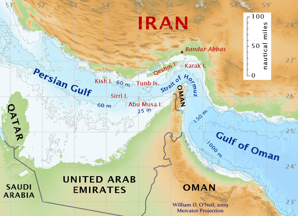
Hörmüz boğazı (Ərəbcə: مَضيق هُرمُز Maḍīq Hurmuz, Farsca:تَنگِه هُرمُز Tangeh-ye Hormoz) Oman körfəzi ilə Fars körfəzi arasında strateji cəhətdən əhəmiyyətli boğazdır. Boğaz avestada qeyd olunan xeyir tanrısı Hörmüzün adını daşıyır.
Şimal sahilində, İran və cənub sahilində Birləşmiş Ərəb Əmirlikləri və Omanın eksklavı Musandam yerləşir. Boğazın ən ensiz yerindəki genişliyi 54 km (34 mil) dir.[1] Bu neft ixrac edən Fars körfəzinin geniş sahələri üçün açıq okeana yeganə dəniz keçididir və dünyanın strateji cəhətdən ən əhəmiyyətli Tıxanma nöqtələrindəndir.[2]
İstinadlar
[redaktə | mənbəni redaktə et]- ↑ name=UNCLOS-historic>"The Encyclopedia of Earth". National Council for Science and Environment. 2009-03-04 tarixində arxivləşdirilib. İstifadə tarixi: 2012-01-23., eoearth.org
- ↑ "Strait of Hormuz". World Oil Transit Chokepoints. U.S. Energy Information Administration. Dec. 30, 2011. November 14, 2013 tarixində arxivləşdirilib. İstifadə tarixi: January 14, 2012.
Əlavə oxumaq
[redaktə | mənbəni redaktə et]- Wise, Harold Lee. Inside the Danger Zone: The U.S. Military in the Persian Gulf 1987-88. Annapolis: Naval Institute Press. 2007. ISBN 1-59114-970-3.
Xarici keçidlər
[redaktə | mənbəni redaktə et]- Robert Strauss Center's Hormuz website: background on the political, economic, business, technical, and military issues Arxivləşdirilib 2009-02-01 at the Wayback Machine
- Strait of Hormuz website Arxivləşdirilib 2020-08-07 at the Wayback Machine, includes antique maps.
- Federation of American Scientists about the weapons on the islands FAS.org
- Strait of Hormuz – U.K. Admiralty Chart 2888 (excerpt) (1580 pixels)
- How Great a Concern? Iranian threats to close the Strait of Hormuz, briefly describes offense-defense balance in the Strait and links to articles in the journal, International Security, as well as a map of the Strait and surrounding region